Beinn a' Chlachair, Geal Chàrn & Creag Pitridh


Beinn a' Chlachair, Geal Chàrn & Creag Pitridh
Scotland
🚲 Bike and Hike: ✅
🏕️ Camp: lots of area for pitching a tent
💧 Water Source: Stream, Burns
🏊 Cold Water: ✅
Route Description:
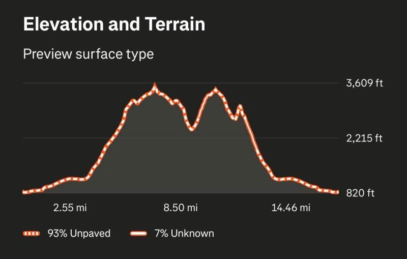
From Dalwhinnie, follow estate tracks and moorland paths southwest toward Beinn a’ Chlachair. Ascend the steep grassy and rocky slopes to reach the summit (1,115 m), then continue along connecting ridges to Geal Chàrn (1,100 m) and Creag Pitridh (1,060 m), passing minor tops and occasional rocky sections. The terrain is open moorland with steep slopes and good views over Loch Ericht, Loch Laggan, and surrounding Highland peaks. Return by retracing the ridge and descending via the same tracks back to Dalwhinnie.
(Munro) Beinn a'Chlachair 1087 meters
Lat, Long 56.869104, -4.510066
OS Grid RefNN471781
(Munro) Geal Charn 1049 meters
Lat, Long 56.897105, -4.457751
OS Grid Ref NN504811
(Munro) Creag Pitridh 924 meters
Lat, Long 56.899246, -4.485811
OS Grid Ref NN487814
16 miles 6-8 hours
bog***
hike***
deer stalking enquires 01528 544300
Submit Walkers Reports
Mountain, Scottish, hill, munrobagging, munro weather, munro parking, distance, time.